commercial drone services in India
Commercial Drone Services in India: 15 Ways Businesses Can Use Drones
Drones are no longer limited to photography and videography.
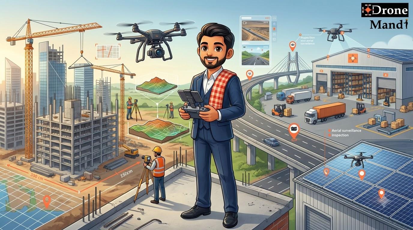
Businesses across India are increasingly using drones for surveying, mapping, inspections, construction monitoring, surveillance, agriculture, infrastructure documentation, industrial applications and other specialized requirements.
The biggest advantage of using a drone commercially is simple: it can collect information or capture imagery from the air much faster and from perspectives that can be difficult, expensive or time-consuming to achieve using traditional methods.
However, a drone itself is only one part of the solution. For commercial projects, businesses often need the right drone, camera, experienced pilot, flight planning, data processing and appropriate operational permissions.
This is where professional commercial drone services in India become useful.
What Are Commercial Drone Services?
Commercial drone services are professional drone operations performed for a business, organization or project rather than for personal recreational use.
The service may involve simply capturing aerial photographs, or it may include a complete workflow involving data collection, processing, analysis and reporting.
For example, a construction company may hire a drone service to:
- Capture weekly aerial photographs
- Monitor construction progress
- Create site maps
- Measure selected areas
- Document completed work
- Inspect difficult-to-access structures
Similarly, an industrial company may use drones for inspection, thermal imaging, infrastructure documentation or aerial monitoring.
The actual service depends on the business objective.
Why Are Businesses Using Drones?
Traditional methods of collecting information from large sites can require significant time, manpower and equipment.
A drone can provide an aerial perspective quickly and can cover areas that may otherwise require extensive ground movement.
For businesses, some of the major benefits include:
- Faster visual data collection
- Large-area aerial coverage
- High-resolution imagery
- Better site documentation
- Access to difficult viewpoints
- Repeatable data collection
- Support for surveying and mapping
- Support for inspection workflows
- Reduced need for certain manual observations
- Better visual communication with stakeholders
The actual benefit depends on the application and how the drone data is incorporated into the company's workflow.
15 Ways Businesses Can Use Commercial Drone Services
1. Commercial Drone Photography
Aerial photography is one of the most common commercial drone applications.
Businesses can use drone photographs for marketing, property documentation, project records, infrastructure documentation, real estate, tourism, events and many other purposes.
High-resolution aerial images can provide a perspective that conventional ground photography cannot easily reproduce.
For example, a real estate developer can use aerial photographs to show the complete property, surrounding roads, landscaping and development from above.
Professional drone photography is also useful for corporate campuses, hotels, resorts, factories, construction projects and commercial properties.
2. Commercial Drone Videography
Drone video is widely used in advertising, corporate films, real estate marketing, events, tourism and brand campaigns.
Moving aerial footage can show the scale and surroundings of a location while creating a more cinematic presentation.
Businesses can hire professional drone videographers when they need controlled camera movement, planned flight paths and high-quality aerial footage.
3. Drone Survey Services
Surveying is another major commercial application.
Drones can capture large numbers of overlapping images that can be processed into useful survey outputs depending on the equipment, methodology and project requirements.
Commercial drone surveys can be used for:
- Construction sites
- Land development
- Earthwork
- Infrastructure projects
- Mining areas
- Stockpile measurement
- Topographic documentation
For survey-grade projects, businesses should work with professionals who understand flight planning, image overlap, ground control, positioning technology and the required accuracy.
4. Drone Mapping
Drone mapping converts aerial imagery into digital geographic information and other mapping outputs.
Depending on the project, outputs may include:
- Orthomosaic maps
- Digital surface models
- Digital terrain models
- Point clouds
- 3D models
- Topographic maps
- Site measurements
Construction companies, surveyors, infrastructure developers, mining companies and land developers can use drone mapping to understand large sites more efficiently.
5. Construction Drone Monitoring
Construction is one of the strongest commercial applications for drones.
A construction company can use regular drone flights to create a visual record of project progress.
Drone monitoring can help teams document:
- Site progress
- Building structure
- Earthwork
- Material storage
- Road development
- Equipment locations
- Site boundaries
When flights are performed consistently, the company can compare imagery from different dates and create a visual timeline of the project.
6. Infrastructure Inspection
Drones can provide visual access to infrastructure that may be difficult or expensive to inspect from the ground.
Applications can include:
- Bridges
- Buildings
- Industrial structures
- Communication towers
- Roofs
- Solar installations
- Selected electrical infrastructure
- Road infrastructure
A drone can capture detailed photographs and video from multiple viewpoints, allowing engineers or maintenance teams to review the imagery.
7. Industrial Drone Inspection
Factories and industrial facilities often contain large structures, equipment and difficult-to-access areas.
Professional drone inspection can help collect visual information from selected external areas without requiring personnel to physically access every viewpoint.
Depending on the requirement, businesses may use standard RGB cameras or specialized sensors such as thermal cameras.
8. Drone Surveillance and Monitoring
Businesses with large properties can use drones as an additional monitoring layer.
Potential applications include:
- Perimeter observation
- Warehouse monitoring
- Construction site monitoring
- Industrial property monitoring
- Large land monitoring
- Event monitoring
Drone surveillance is generally best used alongside existing security systems such as CCTV and physical security personnel rather than treated as an automatic replacement for them.
9. Agriculture Drone Services
Agriculture is another important area where drones can provide useful aerial information.
Depending on the equipment and application, agricultural drones can support:
- Crop monitoring
- Field imaging
- Crop health assessment
- Plantation monitoring
- Field mapping
- Selected agricultural spraying applications
The appropriate drone and workflow depend heavily on the crop, field size, purpose and required data.
10. Thermal Drone Services
Thermal cameras provide information that ordinary cameras cannot.
A thermal drone can detect differences in infrared radiation and can support specialized applications in areas such as:
- Solar inspection
- Industrial inspection
- Building diagnostics
- Electrical inspection
- Selected infrastructure applications
Thermal imagery requires proper interpretation. A temperature difference does not automatically mean that an asset has failed or that a particular fault exists.
Businesses should therefore define the inspection objective and required reporting before hiring a thermal drone service.
11. Real Estate Drone Services
Real estate businesses can use drones to showcase properties from a completely different perspective.
Drone photography and video can show:
- Property surroundings
- Road connectivity
- Land area
- Building exteriors
- Landscaping
- Large residential developments
- Commercial properties
Aerial content can be particularly useful for large plots, farmhouses, resorts, villas, commercial developments and large residential projects.
12. Event and Wedding Drone Services
Drones have become increasingly popular for weddings, corporate events, festivals and other outdoor events.
Businesses and event professionals can use drones for:
- Aerial event photography
- Cinematic wedding videos
- Venue shots
- Guest and crowd-wide shots
- Venue establishing footage
- Special drone-based experiences
Specialized services can also include concepts such as drone flower showers and FPV-based wedding experiences, subject to appropriate planning and operating conditions.
13. Mining and Stockpile Monitoring
Mining and material-handling businesses can benefit from frequent aerial documentation of large sites.
Drone mapping and surveying can support workflows involving:
- Stockpile measurement
- Quarry documentation
- Site mapping
- Earthwork monitoring
- Excavation monitoring
- Progress documentation
For measurement-focused projects, the required accuracy and methodology should be established before the flight.
14. Road and Highway Projects
Road and infrastructure projects can extend across long distances, making traditional site documentation time-consuming.
Drones can capture aerial imagery of selected road sections and support:
- Construction progress monitoring
- Road alignment documentation
- Earthwork monitoring
- Site mapping
- Infrastructure inspection
- Visual project documentation
Regular flights can also create a visual record of how the project changes over time.
15. Custom Drone Services
Not every commercial requirement fits into a standard service category.
Businesses may have unique requirements involving a particular camera angle, difficult-to-access location, specialized drone platform, custom payload or unusual aerial filming requirement.
In these situations, a custom drone service can be designed around the project.
The first step is to explain the desired outcome rather than simply asking for "a drone."
A professional drone service provider can then determine what aircraft, camera, pilot and workflow may be appropriate.
Commercial Drone Services by Industry
| Industry | Common Drone Applications |
|---|---|
| Construction | Progress monitoring, surveying, mapping, inspection |
| Real Estate | Aerial photography, videography, property marketing |
| Infrastructure | Inspection, mapping, documentation, monitoring |
| Manufacturing | Industrial inspection, site monitoring, documentation |
| Mining | Surveying, mapping, stockpile measurement, monitoring |
| Agriculture | Crop monitoring, mapping, imaging and selected spraying applications |
| Events | Aerial photography, videography and event documentation |
| Hospitality | Property photography, resort videos and promotional content |
| Energy | Solar and infrastructure inspection, thermal applications |
| Logistics | Facility monitoring, warehouse documentation and site observation |
How Much Do Commercial Drone Services Cost in India?
There is no single price for commercial drone services in India because the cost depends heavily on the application.
A simple aerial photography assignment and a survey-grade mapping project are completely different services and should not be priced in the same way.
For standard drone photography and videography requirements, practical market planning ranges can often start around:
| Drone Type | Typical Planning Range |
|---|---|
| Standard drone | ₹5,000–₹8,000 per session |
| Standard drone | ₹9,000–₹13,000 per day |
| Advanced drone | Approximately 1.5–2× standard drone rates |
| FPV drone | Often starts around ₹10,000 and can exceed ₹30,000–₹50,000 for specialized shots |
These are practical planning ranges rather than fixed nationwide tariffs.
Surveying, mapping, inspection, thermal imaging, industrial monitoring and other specialized commercial drone services are usually quoted according to the project scope.
What Affects Commercial Drone Service Pricing?
- Drone type: Different drones have different capabilities and operating costs.
- Camera: Specialized cameras can increase the project cost.
- Location: Travel and logistics can affect pricing.
- Duration: Longer assignments require more operating time.
- Area: Large sites may require more flights and planning.
- Deliverables: Edited video, maps, models and reports may add to the scope.
- Accuracy: Survey-grade work can require specialized positioning and ground control.
- Frequency: Recurring monitoring involves multiple site visits.
- Site complexity: Industrial and congested environments may require additional planning.
Drone Rental vs Commercial Drone Service
Businesses sometimes assume that renting a drone is cheaper than hiring a professional service.
That is not always the case.
A drone rental gives the customer access to equipment. A commercial drone service typically provides the equipment along with an experienced operator and a defined deliverable.
| Factor | Drone Rental | Commercial Drone Service |
|---|---|---|
| Drone | Customer uses rented equipment | Provider supplies appropriate equipment |
| Pilot | May not be included | Professional operator included |
| Flight planning | Customer responsibility | Usually handled by provider |
| Data capture | Customer responsibility | Provider handles capture |
| Specialized work | More difficult without experience | Provider can plan around the requirement |
For businesses without in-house drone expertise, hiring a complete drone service can be more practical.
How to Hire a Commercial Drone Service in India
The best way to hire a drone service is to start with the business problem rather than the drone model.
1. Define Your Objective
Explain what you want to achieve.
For example:
- "I need weekly construction progress photos."
- "I need a map of this land parcel."
- "I need aerial video for our real estate project."
- "I need an inspection of our warehouse roof."
- "I need thermal inspection of our solar installation."
2. Share the Location
The project location is important because operating conditions, surrounding infrastructure and applicable requirements can vary.
3. Explain the Area and Duration
Tell the provider approximately how large the site is and how long you expect the operation to take.
4. Specify the Deliverables
Clarify whether you require photographs, raw video, edited video, maps, 3D models, thermal imagery, measurements or reports.
5. Ask About Equipment
The right drone depends on the application.
A small camera drone may be ideal for a marketing shoot but completely unsuitable for a survey-grade mapping project.
6. Check Pilot Experience
For commercial operations, experience matters.
Ask whether the pilot has handled similar projects and whether the provider understands the requirements of the specific site.
7. Discuss Safety and Regulatory Requirements
Drone operations should be planned according to the applicable regulations, airspace conditions, site restrictions and safety requirements.
Requirements can vary depending on the aircraft, location, nature of the operation and other factors.
8. Compare the Complete Quote
Do not compare only the flight price.
Check what is included in the quotation:
- Pilot
- Drone
- Camera
- Travel
- Flight time
- Raw footage
- Editing
- Mapping or processing
- Reports
- Additional site visits
Why Businesses Choose Drone Mandi
One of the biggest challenges with commercial drone projects is finding the right person for the specific requirement.
A business may know that it needs "a drone," but the actual requirement could be photography, mapping, surveying, inspection, surveillance or something completely different.
Drone Mandi is an Indian drone marketplace that helps customers connect with drone professionals for commercial and specialized aerial requirements.
Instead of separately searching for a drone, pilot and service provider, businesses can share their requirement and find a suitable drone professional.
Drone Mandi's service ecosystem covers requirements including:
- Drone photography
- Drone videography
- Drone surveys
- Drone mapping
- Drone inspections
- Construction monitoring
- Drone surveillance
- Event drone services
- Industrial drone services
- Custom drone services
Looking for a Commercial Drone Service?
Whether you need aerial photography, videography, surveying, mapping, inspection, construction monitoring, surveillance or a custom drone solution, Drone Mandi helps you connect with drone professionals across India.
Share your requirement and find the right drone professional for your project.
Commercial Drone Services Across India
Commercial drone services are increasingly relevant across India's major business, construction and industrial markets.
Drone professionals can be required for projects in cities and regions including:
- Delhi
- Gurgaon
- Noida
- Bangalore
- Mumbai
- Pune
- Chennai
- Ahmedabad
- Hyderabad
- Kolkata
- Jaipur
- Other Tier 1, Tier 2 and Tier 3 cities
Availability depends on the specific location, project requirements, operator network and applicable operating conditions.
One Drone Can Support Multiple Business Requirements
An important advantage of building a relationship with a professional drone service provider is that the same business may eventually need several different aerial services.
For example, a construction company could initially hire a drone for progress photography.
Later, the same project might require:
- Drone surveying
- 3D mapping
- Stockpile measurement
- Roof inspection
- Thermal inspection
- Site documentation
Rather than treating every requirement as a completely separate search, businesses can work with a drone service marketplace or provider capable of understanding the broader project.
When Should a Business Hire a Drone Service?
A drone service can make sense when aerial information provides a meaningful advantage over traditional ground-based methods.
Consider hiring a commercial drone service when:
- You need a large-area aerial view.
- You need high-resolution aerial photographs.
- You need regular project documentation.
- You need mapping or survey data.
- You need to inspect difficult-to-access structures.
- You need specialized thermal imagery.
- You need construction progress monitoring.
- You need aerial marketing content.
- You need monitoring of a large property.
- You have a custom aerial requirement.
Common Mistakes Businesses Make When Hiring Drone Services
Choosing the Cheapest Pilot
Commercial drone work is not always a commodity service. Equipment, experience, data quality and deliverables can significantly affect the final result.
Not Explaining the Actual Requirement
Saying "I need a drone" is often not enough.
Explain what you want to capture or measure so the provider can select the right equipment and workflow.
Using the Wrong Drone
A drone suitable for photography may not be appropriate for mapping, thermal inspection or another specialized application.
Ignoring Deliverables
Clarify whether you need raw images, edited videos, maps, measurements, 3D models or reports before the project starts.
Not Planning Recurring Work
If the project requires weekly or monthly monitoring, discuss the complete recurring workflow instead of booking individual flights without a consistent methodology.
Ignoring Site Conditions
Buildings, cranes, power infrastructure, trees, crowds and other obstacles can affect drone operations.
A professional provider should evaluate the operating environment before the flight.
The Future of Commercial Drone Services in India
Commercial drone applications are moving beyond simple aerial photography.
As drones, cameras, positioning systems, mapping software and data-processing platforms improve, businesses can use aerial systems for increasingly specialized workflows.
Construction companies can combine regular imagery with mapping and progress tracking.
Industrial companies can combine visual inspection with thermal information.
Agricultural businesses can combine aerial imagery with field-level analysis.
Infrastructure companies can use recurring drone data to create a visual history of large projects.
The broader trend is clear: the commercial value of drones increasingly comes from the data and workflow they provide, not simply from the drone flight itself.
Frequently Asked Questions
What are commercial drone services in India?
Commercial drone services are professional drone operations performed for businesses and organizations. They can include photography, videography, surveying, mapping, inspection, surveillance, construction monitoring, agriculture and specialized aerial projects.
How much do commercial drone services cost in India?
Pricing depends on the drone, camera, location, duration, area, pilot, deliverables and complexity of the project. Standard drone photography services may commonly fall around ₹5,000–₹8,000 per session or ₹9,000–₹13,000 per day, while specialized projects are generally quoted separately.
What businesses use commercial drones?
Construction companies, real estate businesses, infrastructure companies, manufacturers, mining companies, agricultural businesses, event companies, logistics facilities, energy companies and many other organizations can use commercial drone services.
Can I hire a drone with a pilot in India?
Yes. Businesses can hire a complete drone service where the provider supplies the appropriate drone and an experienced pilot for the project.
Can drones be used for construction monitoring?
Yes. Construction companies can use drones for aerial photography, progress monitoring, surveying, mapping, inspections and visual project documentation.
Can drones be used for industrial inspections?
Yes. Professional drones can capture visual information from selected industrial structures and difficult-to-access areas. Specialized cameras such as thermal cameras may be used for certain applications.
Can drones be used for surveying and mapping?
Yes. Drones can capture overlapping aerial imagery that can be processed into mapping and survey-related outputs. The required equipment, positioning technology, ground control and methodology depend on the accuracy and deliverables required.
Can drones be used for business surveillance?
Yes. Drones can provide aerial monitoring for selected business applications such as large-property observation, construction sites, industrial facilities and perimeter monitoring, subject to appropriate planning and applicable requirements.
How do I find a commercial drone service near me?
You can search for local drone professionals or use a drone marketplace such as Drone Mandi to share your requirement and find a suitable drone service provider based on the project.
Why should I hire a drone service instead of buying a drone?
Hiring a professional service can be more practical when the business only needs occasional aerial work or requires specialized equipment, experienced piloting, flight planning, data processing or specific project deliverables.
Conclusion
Commercial drones have evolved into useful business tools across a wide range of industries.
From photography and videography to surveying, mapping, inspections, construction monitoring, surveillance, agriculture and thermal imaging, businesses can use drones to collect aerial information and create outputs that support marketing, operations, engineering and decision-making.
The most important question is not simply "Which drone should we buy?"
It is:
Once the objective is clear, it becomes much easier to determine the appropriate drone, camera, pilot, flight plan and deliverables.
For businesses that do not want to build an in-house drone operation, hiring a professional drone service can be a practical way to access the required equipment and expertise for a specific project.
Drone Mandi brings these requirements together through an Indian drone marketplace where customers can find professionals for photography, videography, surveying, mapping, inspection, surveillance, construction monitoring and custom drone services.
Need Drone Services?
Get in touch with us to book certified drone pilots anywhere in India.